The Accursed Mountains: Albania, Kosovo, Montonegro
Self-Guided Peaks of the Balkans: 11 Days Trek
Overview
Distance
145km
Duration
11 Days
Difficulty
Grade II
Price
From £795
Type of Trek
Self-Guided
Accommodation
Mountain huts, guesthouses, hotels
Food
Full board

What is the Self-Guided Peaks of the Balkans?
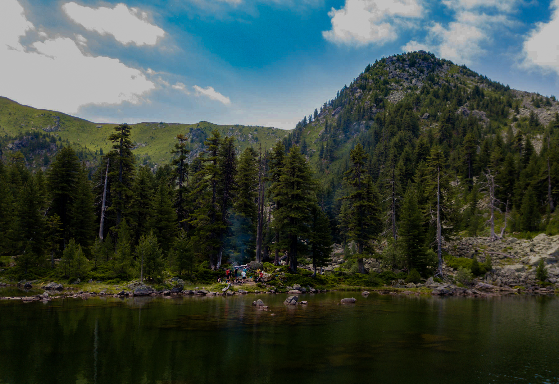
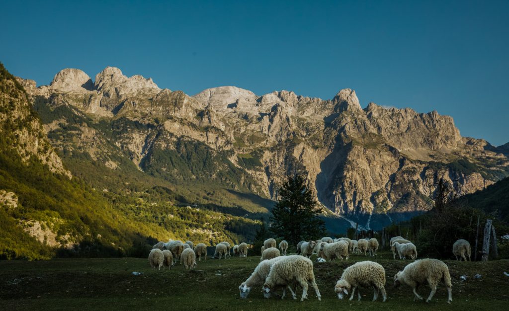
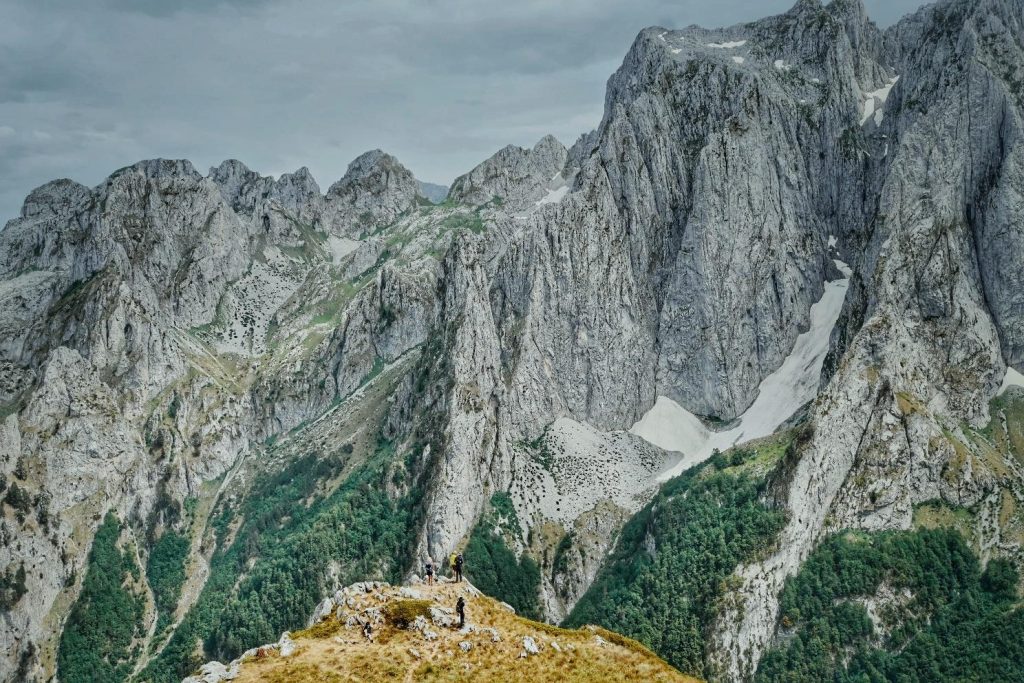
Peaks of the Balkans is the first lengthy hiking trail to traverse the Western Balkans, an area where ancient tracks connect remote regions. The epic walk passes through villages, separated by strict borders and fortified by bunkers that were built over two generations when communist regimes-controlled Yugoslavia and Albania. Winding through meadows, mountain peaks, lakes and woodlands, this is one of the most diverse walking trails in the world. The views and the trails transform, switching from rocky paths and bare peaks to meadows rich with flowers and plants, where nature has been left to run wild. In a stark comparison to Western Europe, here the grass in not cut, and the land is left alone for nature to follow its course.
The trail can be changed and there are a lot of versions which go through the classical trail designed by German GIZ with local consultants, or it can go through other villages and trails off the main track.
You should ensure you are physically prepared and have an interest in remote and challenging environments. Some previous experience is required, as the Peaks of the Balkans is a hiking trail where you are expected to walk for approximately 6 – 8 hours each day, and for several days continuously. Please check the kilometers and the altitude change to self-evaluate the trail difficulty. The German experts have marked this trail as a moderate trail.
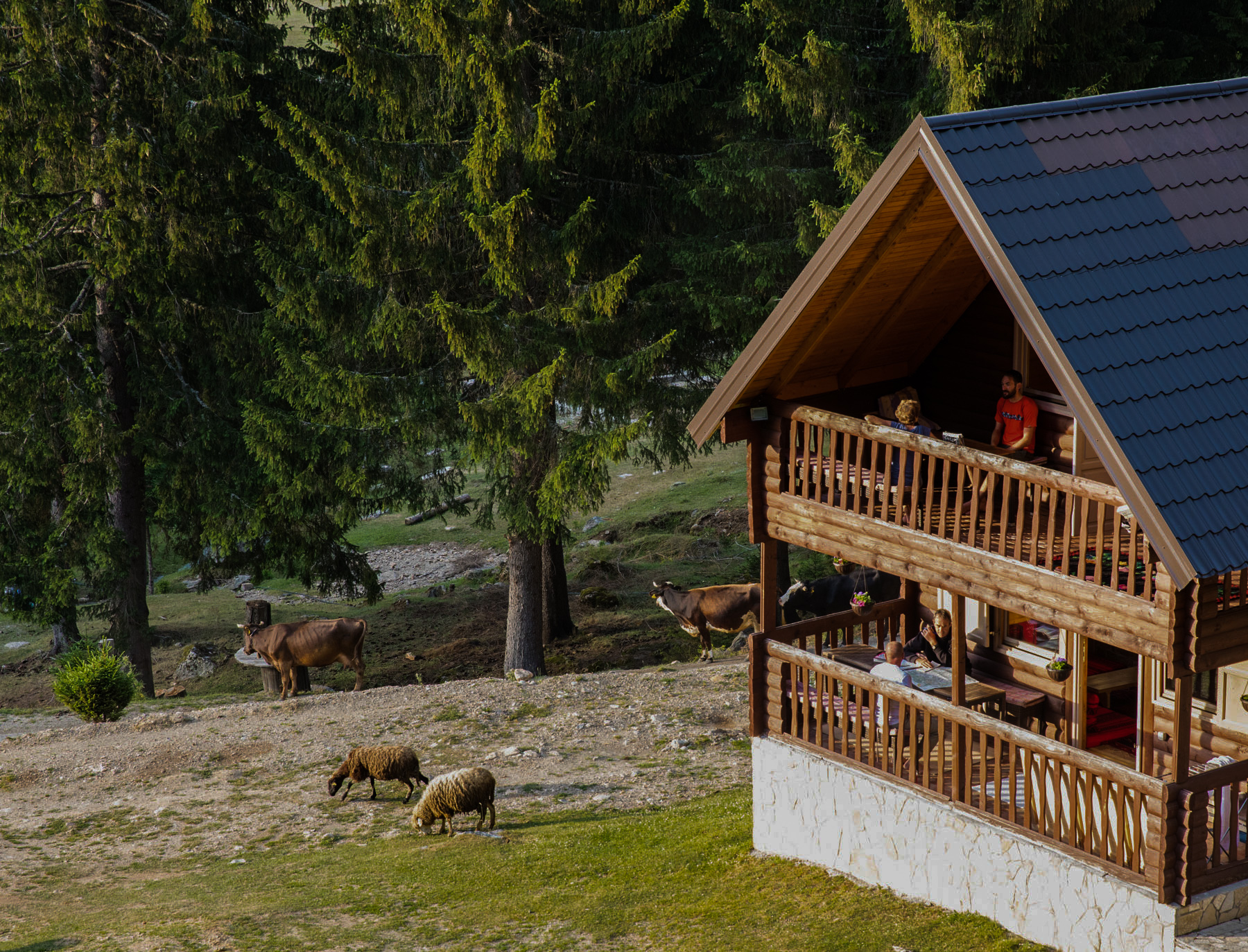
Homestay and guesthouse accommodation in the mountains is simple and this area of the Balkans still observes a very traditional way of life.
Price Information
Itinerary
Day 1: Arrival in Shkoder
Your trip begins with your arrival in the lively city of Shkoder, a cultural and historical gem of Albania.
Upon arrival, you’ll check into the hotel booked for you and settle in. Take the rest of the day to explore the city at your own pace, soaking in its charming atmosphere before the adventure ahead.
The pick-up transfer from the airport or any city can be provided on demand.
Day 2: Transfer Shkoder - Theth. Hike Theth - Nderlyse
Key Hiking Stats Elevation Profile
- Distance: 19.8km (12.30 mi)
- Uphill cumulative: 520m (1710ft)
- Downhill cumulative: 630m (2066ft)
- Minimal elevation: 870m (2854ft)
- Maximal elevation: 500m (1640ft)
- Difficulty level: easy/moderate
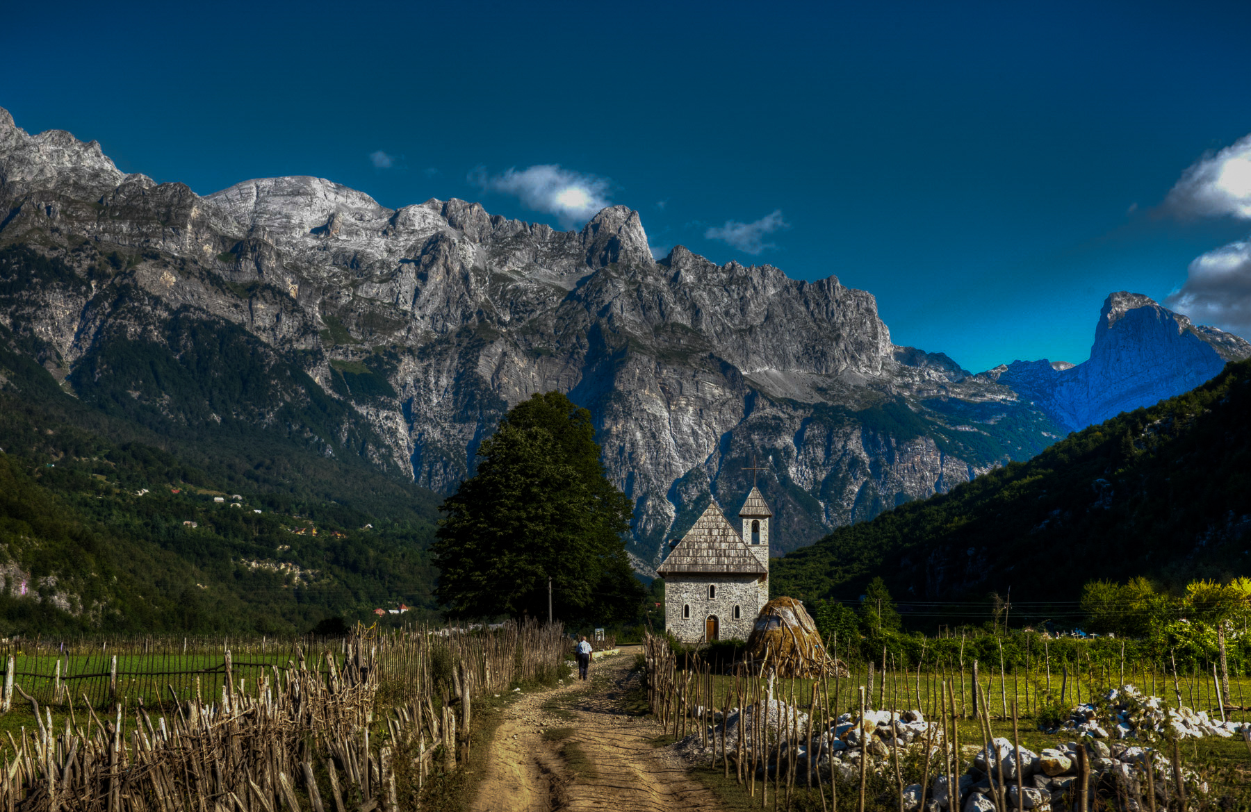
Starting early in the morning with a transfer, this day will take you to the starting point of the trail. The village of Theth is one of the most picturesque places in Northern Albania. Preserved by its wild surroundings, the village still features traditional kullas and other buildings dating back to the Middle Ages. The village is entirely Roman Catholic and is home to one of its most unique structures, the Kulla e Ngujimit. This three-story stone building, with no windows, served as a place of self-imposed isolation for people involved in blood feuds.
You will spend the day walking through the village towards the waterfalls and the naturally formed “bathtubs” of the Shala River. This is a relaxing walk rich in both cultural and natural beauty.
Meals Included: B, L
Day 3: Hike Theth - Valbona
Key Hiking Stats Elevation Profile
- Distance: 16.6 km (10.31 mi)
- Uphill cumulative: 1175m (3855ft)
- Downhill cumulative: 940m (3083ft)
- Minimal elevation: 730m (2390ft)
- Maximal elevation: 1854m (6082ft)
- Difficulty level: moderate/challenging
After a well-earned rest, prepare for an exciting day ahead as you hike to Valbona Pass (1,759m) and descend into the village of Valbona (995m), located in the heart of the national park. This 16 km route follows an ancient mule track that once connected the tribal regions of Shala and Nikaj.
The trail climbs steadily through forest and alpine terrain before reaching the pass, where you are rewarded with spectacular views over both valleys. This section is considered one of the highlights of the Peaks of the Balkans, offering dramatic mountain scenery and a true sense of crossing between remote regions.
After the ascent, you will descend gradually towards the Valbona Valley, following a well-defined path all the way to the village. Although the climb to the pass is challenging, the overall hike is very rewarding and manageable at a steady pace.
Along the way, you move between historically distinct regions, once shaped by different cultural and religious influences. These mountain communities have preserved their traditions and way of life for centuries, adding a unique cultural dimension to the hike.
Upon arrival in Valbona, you will settle into your guesthouse and enjoy a well-deserved meal after this memorable day in the mountains.
Meals Included: B, L, D
Day 4: Hike Valbona - Cerem
Key Hiking Stats Elevation Profile
- Distance: 16.3 km (10.12 mi)
- Uphill cumulative: 1215m (3986ft)
- Downhill cumulative: 1005m (3297ft)
- Minimal elevation: 1215m (3985ft)
- Maximal elevation: 2039m (6689ft)
- Difficulty level: Challenging
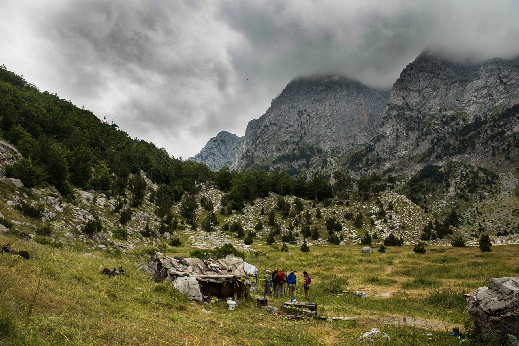
There are two possible routes from Valbona to Cerem: the ‘low/official’ (valley) route and the spectacular, the ‘high/optional’ route via Presllopi Pass (the one we offer).
This trail is one of the steepest ones in the whole Peaks of the Balkans but it offers at the same time the most spectacular view in Accursed Mountains bare stone harsh peaks instead of pretty much opposite of the official section which mostly follows a tractor dirt road down the valley offering very little to see. Persllopi Pass is also a cross-point from where it’s possible to climb the Zla Kollata Peak (2535m) which is the highest peak in Montenegro and offers a breathtaking view on Accursed Mountains.
Meals Included: B, L, D
Day 5: Hike Cerem - Doberdol
Key Hiking Stats
- Distance: 16.8 km (10.43 miles)
- Uphill cumulative: 1020m (3608ft)
- Downhill cumulative: 520m (1706ft)
- Minimal elevation: 1150m (3871ft)
- Maximal elevation: 1920m (6299ft)
- Difficulty level: moderate/challenging
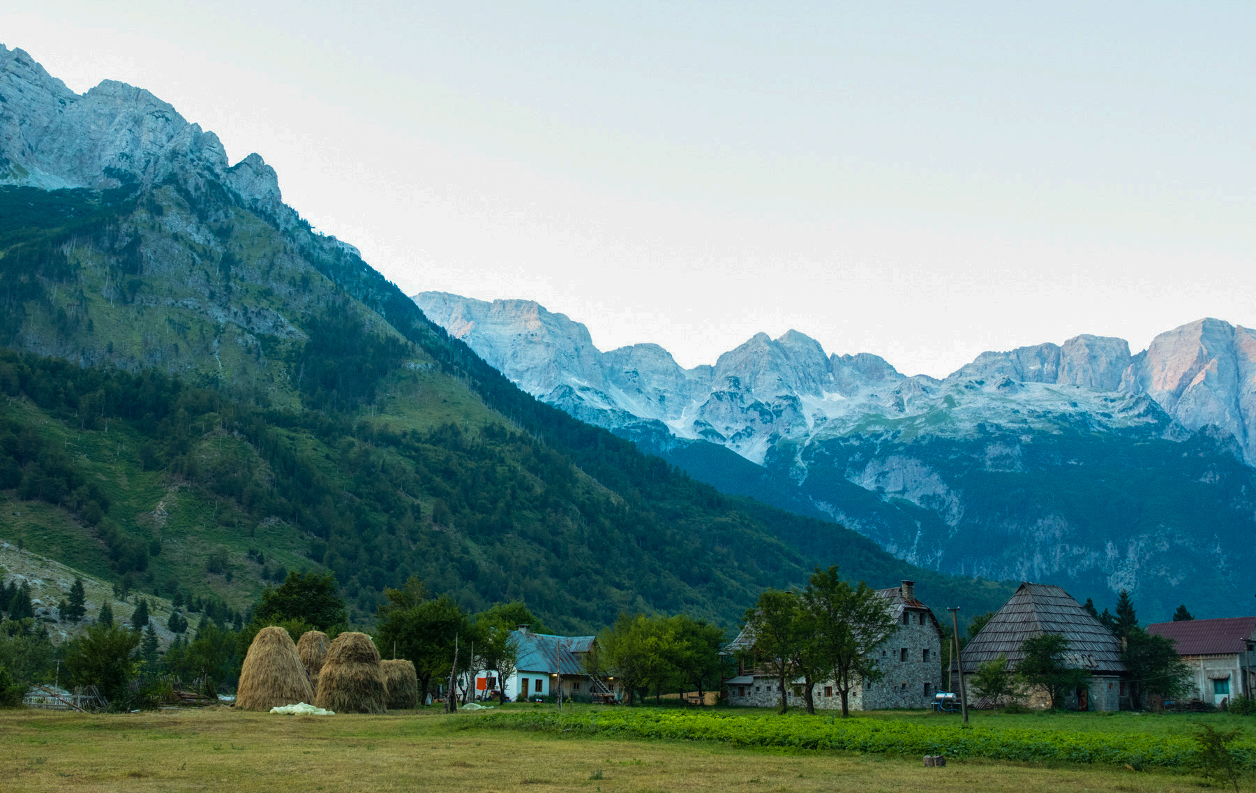
Refreshed, you will walk between two shepherd’s villages which are inhabited only during the summer so that shepherds can use the abundant pastures. Doberdol is connected to the world only by small tracks, and is not reachable by regular cars. The village is situated below the triple-border point between Albania, Kosovo, and Montenegro. On the way you will pass through the village of Balqin where you can stop for a glass of milk served by the local shepherds. These mountains are part of the Gashi valley from where the Gashi tribe comes from, and are under strict protection, as they are also home to glacial lakes of Sulbica platou. Gashi valley was included in UNESCO Natural World Heritage list in 2017.
Your day will end in a cozy accommodation place in Doberdol.
Meals Included: B, L, D
Day 6: Hike Doberdol - Gjeravica peak - Doberdol
Key Hiking Stats
- Distance: 18.8 km (11.80 mi)
- Uphill cumulative: 1134m (3720ft)
- Downhill cumulative: 1130m (3707ft)
- Minimal elevation: 1765m (5790ft)
- Maximal elevation: 2656m (8714ft)
- Difficulty level: challenging
After you have had your rest, during this trail you will be climbing Gjeravica peak (2656m), the highest mountain of Kosovo and the second highest of the Accursed Mountains, after Jezerca peak. The route to the summit from Doberdol is a straightforward hike. This is a loop path that will take you to Kosovo, a border which is almost not protected at all. However, during the communist regimes in this part of the world, this was the border between Albania and Yugoslavia and one of the most protected borders in the world.
When the hike is finished, you will have a restful evening and prepare for your next hike.
Meals Included: B, L, D
Day 7: Hike Doberdol - Milisevc
Key Hiking Stats
- Distance: 17.9 km (11.12 mi)
- Uphill cumulative: 970m (3182ft)
- Downhill cumulative: 1075m (3526ft)
- Minimal elevation: 1535m (5032ft)
- Maximal elevation: 2250m (7381ft)
- Difficulty level: moderate/challenging
Another beautiful day of hiking will take you between two shepherds’ villages in two different countries, however sharing the same culture and language.
These two valleys have been connected by culture but disconnected by political borders. During your hike, you will reach the narrow pass on the border with Montenegro, from which the views are spectacular. From here, you will be climbing the 2366m Three Border peak.
This part of the mountain is very well protected because, from Milisevc, you are connected to the biggest city next to the mountain, Peja, which we also call the capital city of the Accursed Mountains. The hosts of the guesthouse where you will be accommodated will make your stay worthwhile as you take your time to rest.
Meals Included: B, L, D
Day 8: Hike Milisevc - Babino Polje
Key Hiking Stats
- Distance: 12.9 km (8.01 mi)
- Uphill cumulative: 597m (1958ft)
- Downhill cumulative: 747m (2450ft)
- Minimal elevation: 1508m (4945ft)
- Maximal elevation: 2155m (7070ft)
- Difficulty level: easy/moderate
Saying goodbye to Milisevc, you will leave for a detour from the classic Peaks of the Balkans trail. The company decided to take this in order to avoid some hikes which are less attractive and include some unnecessary car transfers. The hike will go through some of the least trodden trails in the Accursed Mountains in Kosovo, and will join the classic trail in the section Kuqishte – Babino Polje, which will go partly through Zavoj Ravno Selo. This section is the least visited in the whole trail giving you a sense of isolation where the mountains will be all yours. When the day is over, you will reach Babino Polje, a typical Montenegrin shepherd village which is famous for its original dairy products and cuisine.
Meals Included: B, L, D
Day 9: Transfer Babino Polje - Grbaja Valley. Hike to Taljanka peak. Transfer to Vusanje
Key Hiking Stats
- Distance: 9.6 km (5.9 mi)
- Uphill cumulative: 995m (3264ft)
- Downhill cumulative: 1100m (3608ft)
- Minimal elevation: 1140m (3740ft)
- Maximal Elevation 2057m (6748ft)
- Difficulty level: moderate/challenging
Gerbaja Valley situated in Montenegro was considered as the most beautiful valley in Tito’s Yugoslavia, home to now 7 independent states. This part of the trail is a detour from the classic Peaks of the Balkans trail however; we consider it a pity that this valley was left out since it is one of the most panoramic in the whole trail. To start the hike, you will take a 20 minutes transport or if you are staying in Babino Polje, the transport will take a bit longer. The hike will start with a climb to Taljanka peak, a green heaven with a view on Karanfil, a rough rock massive. When the sun sets and you finish the hike you will have witnessed breathtaking scenic views on many bare stone high peaks as you have walked along the ridge and top of the Taljanka peak (2057m) and Popadija (2030m) peaks.
Meals Included: B, L, D
Day 10: Hike Vusanje - Theth with a shortcut to Ropojana Valley. Transfer to Shkoder
Key Hiking Stats
- Distance: 17.8 km (11.06 mi)
- Uphill cumulative: 1140m (3740ft)
- Downhill cumulative: 1400m (4593ft)
- Minimal elevation: 730m (2395ft)
- Maximal elevation: 1740m (5705ft)
- Difficulty level: moderate/challenging
From Vusanje, you will begin the hike back to the historic Albanian village of Theth. The path passes through one of the most rugged parts of the Accursed Mountains, an area that was once a restricted zone during the Communist era.
The hike begins in the direction of the Ropojana Valley, with steep rocky slopes rising on both sides. The valley is quite long and follows a 4WD track for approximately 6.5 km, leading toward Ropojana Lake, which is often dry depending on snowfall during the previous winter. To avoid this long section, a car transfer will be arranged.
Along the way, in addition to the dramatic cliffs that form the backdrop of the hike, you may also see a military bunker and old border crossing signs as you make your way back into Albania.
This is one of the rockiest stages of the trip, offering a diverse landscape of mountains, meadows, and wide-open valley views. The day concludes in Theth, completing the loop.
After the hike, a private transfer will take you back to the city of Shkodra for your final night of the trip.
Meals Included: B, L
Day 11: Departure Day
Enjoy a relaxed breakfast and a final stroll through the streets of Shkodra before making your onward journey.
Meals Included: B
What is included?
- Gps files & Route notes
- Transfers: Shkodra – Theth; Babino Polje – Grbaja Valley – Vusanje; Vusanje – Ropojana Valley; Theth – Shkodra;
- Accommodation: 10 nights in hotel, guesthouse, and mountain hut. In the mountains the rooms are shared!
- Meals: 2nd day breakfast and lunch packet; 3rd to 9th day three meals; 10th day breakfast and lunch packet; 11th day breakfast
- Border permits
- POB map
- 24/7 assistance while on tour
What isn't included?
- Any beverages
- Travel insurance
- Entrance fees for the National Parks
Add ons
Luggage transfer (up to 50 kg in soft bags) £450 |
Transfer Tirana city – Shkodra (up to 4 people per vehicle) £75 per vehicle |
Tirana Airport – Shkodra (up to 4 people per vehicle) £60 per vehicle |
Podgorica city/Podgorica Airport – Shkodra (up to 4 people per vehicle) £55 per vehicle |
Inquire NOW to receive our full in-depth self-guided Peaks of the Balkans Itinerary
Simply fill out the form, and I will be in touch with the full details and next steps. If you’d like to talk things through or ask any questions, a call can easily be arranged at any point.
Frequently Asked Questions
Who is the on ground supplier for this trek?
We have partnered with Balkan Natural Adventure to provide all of our treks across the Balkans. Based in Peja, Kosovo, with a focus on authentic, small-group adventures led by experienced local guides who know the terrain, seasons, and communities of the Western Balkans. They have achieved partner level in Travelife Sustainability Certification, recognised for their long-term efforts regarding sustainability and Corporate Social Responsibility.
Where does the 20% profit donation from this trip go?
The rivers in the Balkans are amongst the most valuable and intact rivers in Europe. As such, they are THE hotspot for the continent’s freshwater biodiversity. These rivers are severely threatened by over 3,400 planned dams, which would irreversibly devastate the last sanctuary for endangered and endemic river species.With the help of local activists, lawyers, scientists, artists and local communities, Save the Blue Heart of Europe aim to prevent this dam tsunami and save this natural European heritage from destruction. 20% of the profit made from each trip to The Balkans will be sent directly to their charity, to help fund the incredible work they do.
What fitness/experience level do I need to complete this trek?
You should be able to walk comfortably for up to 17km a day on uneven, hilly terrain. Some days have significant elevation gains and losses, up to 1,235m per day. It is recommended to train walking uphill (use a stair master if you don’t live in a hilly area) to put yourself in the best position possible.
You May Also Like...

Zagoria Valley Trek Albania: Guided
Nar-Phu Valley Trek